John Lukens
No picture exists of John Lukens. He served as the Surveyor General for the Province of Pennylvania and the Three Lower Counties on Delaware, a position to which he was appointed in 1761. Previously, he served as chain-carrier and 'practical surveyor' for Nicholas Scull.
The land office for Pennsylvania, located in Philadelphia, was closed in 1776 and moved to Lancaster. John Lukens continued in the position of Surveyor General all that time and in those two places.
From 1778 until 1780, the land office was shut down, then during the next year, Lukens was elected to serve as the Surveyor General of a reopened land office. From 1781 until his death in 1789, John Lukens maintained his position.
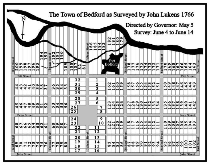
John Lukens laid out only two towns during his career as Surveyor General: Bedford in 1766 and Sunbury in 1772. He included a 'town square' in his survey of Bedford and he conferred with people already residing in the vicinity to determine the size of lots for the town. He utilized the large stone house of Christopher Lems, which was oriented to the four compass points (and the Forbes Road which went ast it) as the basis of his town plat. It is noteworthy that the Commandant's House (variously the King's House and later the Rising Sun Tavern) was also already standing along the south side of Forbes Road, but it was oriented fifteen degrees diagonal to Forbes Road. In order to accommodate that structure, Lukens shifted the frontage of the lots ninety degrees, creating lots fronting on Juliana Street.
A modern sketch, showing the lot numbers, derived from John Lukens' survey completed between 4 and 14 June 1766 is shown below.