
![]() Bedford Township was formed in 1767 within Cumberland County. Frankstown Township was formed in 1775 out of the northern third of Bedford Township and the western half of Barre Township. Woodberry Township was then formed out of the southern third of Frankstown Township in 1785. The part of Woodberry Township that lay west of Dunnings Mountain was removed in 1798 to form Greenfield Township. In the meantime, in 1794, St. Clair Township had been formed from a portion of Bedford Township just south of the portion that went to Frankstown Township; its eastern boundary with Bedford Township lay along the summit of Wills Mountain in the south and Dunnings Mountain in the north. A portion of the northern part of St. Clair Township was removed in 1834 to form Union Township along with a portion of Greenfield Township that had been formed out of Woodberry Township.
Bedford Township was formed in 1767 within Cumberland County. Frankstown Township was formed in 1775 out of the northern third of Bedford Township and the western half of Barre Township. Woodberry Township was then formed out of the southern third of Frankstown Township in 1785. The part of Woodberry Township that lay west of Dunnings Mountain was removed in 1798 to form Greenfield Township. In the meantime, in 1794, St. Clair Township had been formed from a portion of Bedford Township just south of the portion that went to Frankstown Township; its eastern boundary with Bedford Township lay along the summit of Wills Mountain in the south and Dunnings Mountain in the north. A portion of the northern part of St. Clair Township was removed in 1834 to form Union Township along with a portion of Greenfield Township that had been formed out of Woodberry Township.
![]() Two decades prior to Union Township's formation, St. Clair was divided in 1812 along a surveyed diagonal line that left two-thirds in the north remaining as St. Clair and one-third in the south as the new township of Napier.
Two decades prior to Union Township's formation, St. Clair was divided in 1812 along a surveyed diagonal line that left two-thirds in the north remaining as St. Clair and one-third in the south as the new township of Napier.
![]() On 27 November 1839 a number of the inhabitants of Napier Township petitioned the Court of Common Pleas to form a new township out of Napier.
On 27 November 1839 a number of the inhabitants of Napier Township petitioned the Court of Common Pleas to form a new township out of Napier.
![]() To the Honourable the Judges of the Court of Common Pleas of Bedford County comprising a Court of Quarter Sessions in and for said County The petition of the subscribers inhabitants of the Townships of Napier and Londonderry Respectfully Represents That your Petitioners labour under great inconveniences in attending to their Township elections and working out their Road taxes on account of their two townships being too large and inconvenient. We the petioners therefore Pray your Honours to lay off a new Township out of part of said Townships to be called Harrison acording to the following boundaries to wit Beginning at the Bedford and Somerset turnpike in Napier Township at the Bridge across the Raystown branch of Juniata thence along said Branch to the farm of John Mowry from thence a long the dry run to the Somerset County line so as to include John Kelly's farm Thenalong said line to the dividing Ridge in Londonderry Township between tarwater Run and Wolfcamp Run and from that point of said Ridge at Adam Smiths farm a line to Swigertz gap so as to include John Kellermans and Jacob Devores farms from thence taking the dividing waters along the Napier Township line to the place of beginning and we pray your honours to appoint men to lay off said Township agreeable to an act of assembly passed 24 March 1809 empowering the Court of Quarter Session to divide or lay off new Townships and your Petitioners will pray &c.
To the Honourable the Judges of the Court of Common Pleas of Bedford County comprising a Court of Quarter Sessions in and for said County The petition of the subscribers inhabitants of the Townships of Napier and Londonderry Respectfully Represents That your Petitioners labour under great inconveniences in attending to their Township elections and working out their Road taxes on account of their two townships being too large and inconvenient. We the petioners therefore Pray your Honours to lay off a new Township out of part of said Townships to be called Harrison acording to the following boundaries to wit Beginning at the Bedford and Somerset turnpike in Napier Township at the Bridge across the Raystown branch of Juniata thence along said Branch to the farm of John Mowry from thence a long the dry run to the Somerset County line so as to include John Kelly's farm Thenalong said line to the dividing Ridge in Londonderry Township between tarwater Run and Wolfcamp Run and from that point of said Ridge at Adam Smiths farm a line to Swigertz gap so as to include John Kellermans and Jacob Devores farms from thence taking the dividing waters along the Napier Township line to the place of beginning and we pray your honours to appoint men to lay off said Township agreeable to an act of assembly passed 24 March 1809 empowering the Court of Quarter Session to divide or lay off new Townships and your Petitioners will pray &c.
![]() The township of Napier was divided in two in 1840 by an east-west line that basically followed the course of the Raystown Branch of the Juniata River. The northern half, which retained the name of Napier Township, was at that point essentially triangular shaped. The north boundary was defined by a surveyed line from the southeast to the northwest. The south boundary was defined by the Juniata River which flowed from the southwest to the northeast. The western boundary was basically a north to south line. The southern portion took the name of Harrison Township. Its north boundary was the Juniata River. The east boundary was the summit of Wills Mountain. The south boundary was a series of surveyed lines forming a concave curve and the west boundary was a surveyed north to south line.
The township of Napier was divided in two in 1840 by an east-west line that basically followed the course of the Raystown Branch of the Juniata River. The northern half, which retained the name of Napier Township, was at that point essentially triangular shaped. The north boundary was defined by a surveyed line from the southeast to the northwest. The south boundary was defined by the Juniata River which flowed from the southwest to the northeast. The western boundary was basically a north to south line. The southern portion took the name of Harrison Township. Its north boundary was the Juniata River. The east boundary was the summit of Wills Mountain. The south boundary was a series of surveyed lines forming a concave curve and the west boundary was a surveyed north to south line.
![]() During the April Sessions of 1844, a group of men were appointed to view the line dividing Harrison Township from Napier and confirm its bounds. Their report was returned to the Court of Quarter Sessions on 05 February 1845.
During the April Sessions of 1844, a group of men were appointed to view the line dividing Harrison Township from Napier and confirm its bounds. Their report was returned to the Court of Quarter Sessions on 05 February 1845.
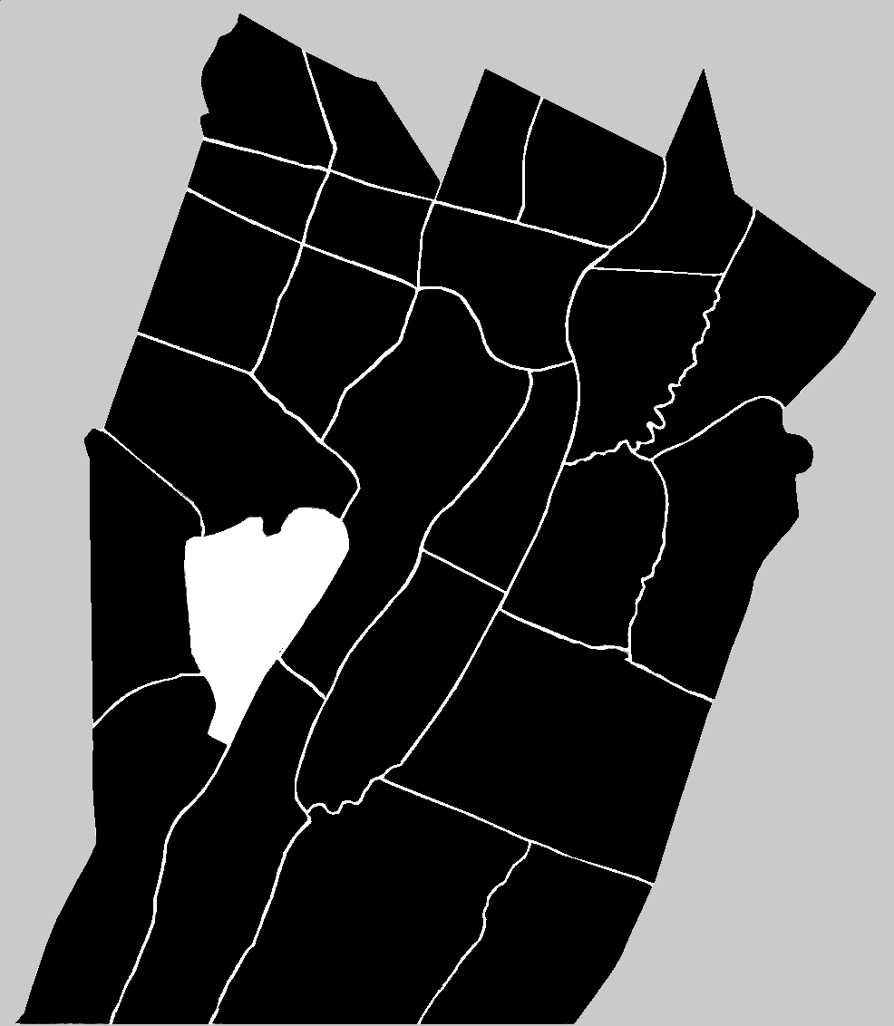
![]() In the year 1853, Harrison Township was divided into east and west halves, with the west being named Juniata and with the east retaining the name of Harrison.
In the year 1853, Harrison Township was divided into east and west halves, with the west being named Juniata and with the east retaining the name of Harrison.
![]() Then, during the May Sessions of 1854, a group of Commissioners named during the previous year's November Sessions presented a report confirming the line between Harrison and the new township of Juniata. An uneven boundary line was replaced by a straight line.
Then, during the May Sessions of 1854, a group of Commissioners named during the previous year's November Sessions presented a report confirming the line between Harrison and the new township of Juniata. An uneven boundary line was replaced by a straight line.
![]() Harrison Township was named in honor of William Henry Harrison. He was running for President in 1840. The southern half of Napier Township was not the first region for which the name 'Harrison' was suggested. In 1837, a petition was presented to the Court of General Quarter Sessions of the Peace and Gaol Delivery by residents of Southampton Township. That petition was a request for a division and the naming of that new township as 'Harrison.' According to the Waterman, Watkins & Company book, the township was formed in the year 1842. According to E. Howard Blackburn in his book on the county's history, Harrison Township was formed in either 1840 or 1841. Blackburn also noted that the line separating the new township from Napier was re-run and not established definitively until 1845. The petition to the Court asking that the line be re-determined noted that "By reason of the Dry Run being made in part the division line between said townships, Which said Run is very crooked in its course; and forks into several branches near the head, so as to render it doubtfull where the right line is." The petitioners requested the line to be run from the mouth of Dry Run in a straight line from the farm of John Mowry to a point on the Somerset County line. The boundary change petition was read by the Court on 24 January 1844. An order to view the proposed new line was issued by the Court on 25 April. It was "Referred back to same viewers who are to go on the ground & view the line together & not separately" on 30 August. The men appointed as commissioners to view the line, John P. Reed, Peter R. Hillegass and Frederick Turner, returned their results on 24 December. On 05 February 1845, the Court noted that it had been "Read and Confirmed absolutely."
Harrison Township was named in honor of William Henry Harrison. He was running for President in 1840. The southern half of Napier Township was not the first region for which the name 'Harrison' was suggested. In 1837, a petition was presented to the Court of General Quarter Sessions of the Peace and Gaol Delivery by residents of Southampton Township. That petition was a request for a division and the naming of that new township as 'Harrison.' According to the Waterman, Watkins & Company book, the township was formed in the year 1842. According to E. Howard Blackburn in his book on the county's history, Harrison Township was formed in either 1840 or 1841. Blackburn also noted that the line separating the new township from Napier was re-run and not established definitively until 1845. The petition to the Court asking that the line be re-determined noted that "By reason of the Dry Run being made in part the division line between said townships, Which said Run is very crooked in its course; and forks into several branches near the head, so as to render it doubtfull where the right line is." The petitioners requested the line to be run from the mouth of Dry Run in a straight line from the farm of John Mowry to a point on the Somerset County line. The boundary change petition was read by the Court on 24 January 1844. An order to view the proposed new line was issued by the Court on 25 April. It was "Referred back to same viewers who are to go on the ground & view the line together & not separately" on 30 August. The men appointed as commissioners to view the line, John P. Reed, Peter R. Hillegass and Frederick Turner, returned their results on 24 December. On 05 February 1845, the Court noted that it had been "Read and Confirmed absolutely."