![]() The Indian Traders of the early-1700s were businessmen. They did not trek into the wilderness laden down with packets and chests filled with tools and trinkets simply for the fun of it. And despite what Hollywood has suggested on the matter, through movies and television series such as Daniel Boone and Davy Crockett, the everyday life of the trader was not one heroic adventure after another. They hunted for food (or planted small gardens), ate, slept and attended to their bodily needs just like anyone else. And because they were conducting a business in their trading activities, most traders made business decisions in most everything they did. One of those business decisions was to choose a spot that would be accessible to their intended customers.
The Indian Traders of the early-1700s were businessmen. They did not trek into the wilderness laden down with packets and chests filled with tools and trinkets simply for the fun of it. And despite what Hollywood has suggested on the matter, through movies and television series such as Daniel Boone and Davy Crockett, the everyday life of the trader was not one heroic adventure after another. They hunted for food (or planted small gardens), ate, slept and attended to their bodily needs just like anyone else. And because they were conducting a business in their trading activities, most traders made business decisions in most everything they did. One of those business decisions was to choose a spot that would be accessible to their intended customers.
![]() John Ray made his way into the frontier that lay to the west of the settlements of the Province of Pennsylvania in the mid-1700s. At the time, a number of Amerindian footpaths connected the forests in what is present-day New York State with the lands to the south in present-day Kentucky and Tennessee. There was a north-south path in every major valley that lay between the mountains of the Appalachians. The Amerindians had also tramped down a path that stretched from the Ohio Valley to the lands in the east being claimed by immigrant Euro~Americans. A primary east-west path traveled through a number of gaps in the mountain ranges, following the course of rivers that cut those gaps. When John Ray arrived in this region, that east-west path bore no name that any Euro~American would have recognized.
John Ray made his way into the frontier that lay to the west of the settlements of the Province of Pennsylvania in the mid-1700s. At the time, a number of Amerindian footpaths connected the forests in what is present-day New York State with the lands to the south in present-day Kentucky and Tennessee. There was a north-south path in every major valley that lay between the mountains of the Appalachians. The Amerindians had also tramped down a path that stretched from the Ohio Valley to the lands in the east being claimed by immigrant Euro~Americans. A primary east-west path traveled through a number of gaps in the mountain ranges, following the course of rivers that cut those gaps. When John Ray arrived in this region, that east-west path bore no name that any Euro~American would have recognized.
![]() The general assumption of most people, historians and non-historians alike, is that John Ray established his trading post on the small hill upon which the fort would be built in 1758. It was suggested, though, in the 1958 Fort Bedford Bicentennial souvenir book, that the trading post would not have been on that small rise. A footnote in that book noted that Judge William Hall had commented on the subject. In his book, Reminiscences, Judge Hall suggested that the trading post had been located "on the flat between Dunning's Creek and the Juniata."
The general assumption of most people, historians and non-historians alike, is that John Ray established his trading post on the small hill upon which the fort would be built in 1758. It was suggested, though, in the 1958 Fort Bedford Bicentennial souvenir book, that the trading post would not have been on that small rise. A footnote in that book noted that Judge William Hall had commented on the subject. In his book, Reminiscences, Judge Hall suggested that the trading post had been located "on the flat between Dunning's Creek and the Juniata."
![]() Judge Hall's suggestion makes a lot of sense. Situated in close proximity to the mouth of Dunning Creek, where it empties into the Juniata River, it would have been ideally situated to be reached by his customers who traveled by canoe and it also would have been located alongside the east-west foot path. To have been located on the summit of the low hill would have placed it a distance from both the water and the land routes normally traveled by the native inhabitants.
Judge Hall's suggestion makes a lot of sense. Situated in close proximity to the mouth of Dunning Creek, where it empties into the Juniata River, it would have been ideally situated to be reached by his customers who traveled by canoe and it also would have been located alongside the east-west foot path. To have been located on the summit of the low hill would have placed it a distance from both the water and the land routes normally traveled by the native inhabitants.
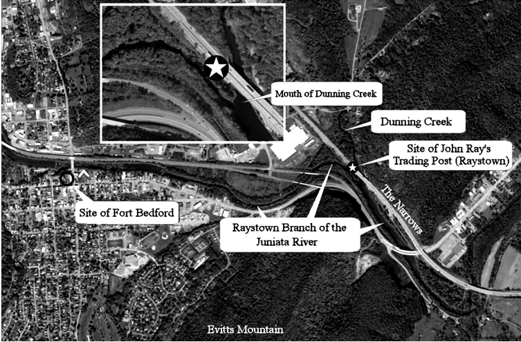
![]() The triangular piece of land defined by the west bank of the Dunning Creek and the northeast bank of the branch of the Juniata River would have been the perfect site for Ray's trading post.
The triangular piece of land defined by the west bank of the Dunning Creek and the northeast bank of the branch of the Juniata River would have been the perfect site for Ray's trading post.
![]() After making his settlement there, Ray provided a name for the branch of the river, the east-west Amerindian path, a nearby mountain and an adjacent valley: Raystown Branch of the Juniata River, the Raystown Path, Rays Hill and Rays Cove. Place names were seldom, if ever, legislated. No court decreed that the path stretching between the eastern counties of Pennsylvania and the Ohio Valley would be named the Raystown Path. It just came about that one cartographer noted it as such, and his map was copied by others.
After making his settlement there, Ray provided a name for the branch of the river, the east-west Amerindian path, a nearby mountain and an adjacent valley: Raystown Branch of the Juniata River, the Raystown Path, Rays Hill and Rays Cove. Place names were seldom, if ever, legislated. No court decreed that the path stretching between the eastern counties of Pennsylvania and the Ohio Valley would be named the Raystown Path. It just came about that one cartographer noted it as such, and his map was copied by others.
![]() An important point needs to be made here. Quite a number of errors have been made in the past when referring to "Raystown" as being a village, and the forerunner of Bedford Town / Borough. The word town is derived from the Old English word tun, which in turn was derived from the Old German word zaun. The word 'zaun' translates into English as 'a fence or wall'. A group of two or more buildings surrounded by a fence or wall would therefore be referred to as a 'town'. The early cartographers denoted the trading posts located throught the frontier regions by adding the word 'town' to the trader's surname. John Wray's trading post became 'Wraystown' (or the usual variation of Raystown). Steven Franks' trading post became 'Frankstown'. Thomas Cresap's trading post became 'Cresapstown'. A trader, whose trading post consisted of a single building not requiring a fence to surround it would not have the word 'town' added to it on a map. James Dunning's trading post was known simply as 'Dunnings'. Historians, who have suggested that a village by the name of 'Raystown' stood on the site now occupied by Bedford Borough, cannot explain what happened to the buildings and people who apparently occupied that mythical village when the British Army came through in the Forbes Expedition.
An important point needs to be made here. Quite a number of errors have been made in the past when referring to "Raystown" as being a village, and the forerunner of Bedford Town / Borough. The word town is derived from the Old English word tun, which in turn was derived from the Old German word zaun. The word 'zaun' translates into English as 'a fence or wall'. A group of two or more buildings surrounded by a fence or wall would therefore be referred to as a 'town'. The early cartographers denoted the trading posts located throught the frontier regions by adding the word 'town' to the trader's surname. John Wray's trading post became 'Wraystown' (or the usual variation of Raystown). Steven Franks' trading post became 'Frankstown'. Thomas Cresap's trading post became 'Cresapstown'. A trader, whose trading post consisted of a single building not requiring a fence to surround it would not have the word 'town' added to it on a map. James Dunning's trading post was known simply as 'Dunnings'. Historians, who have suggested that a village by the name of 'Raystown' stood on the site now occupied by Bedford Borough, cannot explain what happened to the buildings and people who apparently occupied that mythical village when the British Army came through in the Forbes Expedition.
![]() John Ray's trading post was probably constructed as close to the banks of the two waterways as possible. If that was indeed the case, the site of the 'town' would have been located at a point where the Pennsylvania Turnpike crosses over the mouth of Dunning Creek today.
John Ray's trading post was probably constructed as close to the banks of the two waterways as possible. If that was indeed the case, the site of the 'town' would have been located at a point where the Pennsylvania Turnpike crosses over the mouth of Dunning Creek today.
![]() The west half of the site is currently owned by JLG Industries and the east half is owned by Bob Foor according to the Tax Assessment Office at the Bedford County Court House.
The west half of the site is currently owned by JLG Industries and the east half is owned by Bob Foor according to the Tax Assessment Office at the Bedford County Court House.