
![]() Note: On the survey below, north is to the left side.
Note: On the survey below, north is to the left side.
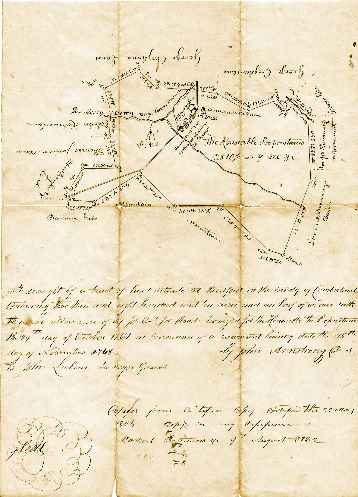
![]() For a period of ninety years, between 1683 and 1773, the Proprietaries of the Colony of Pennsylvania engaged a number of surveyors to lay out seventy-six Proprietary Manors and towns throughout the province of Pennsylvania. As noted in the warrant transcribed above, article number nine of Certain Conditions or Concessions, Agreed upon by William Penn, Proprietary and Governor of the Province of Pennsylvania. . . (issued on 11 July 1681), stated that: "In every hundred thousand acres, the Governor and Proprietary by lot reserveth Ten to himself, which shall lie but in one place." The tract that was surveyed within Cumberland County as the Manor of Bedford amounted to two thousand, eight hundred, and ten and one-half acres. One purpose for which the manors were established was so that the Proprietaries could hold on to an amount of land in their colony which they could sell in the future, and thereby have a source of income when required. Although the practice might not seem just and proper to us today, it must be remembered that the colony of Pennsylvania had been granted to William Penn for his, and his descendants' exclusive use. How they chose to make use of the land, and/or divest themselves of any or all of it, was solely the business of the Penn family. And they chose to retain a number of tracts of land known as 'Proprietary Manors.'
For a period of ninety years, between 1683 and 1773, the Proprietaries of the Colony of Pennsylvania engaged a number of surveyors to lay out seventy-six Proprietary Manors and towns throughout the province of Pennsylvania. As noted in the warrant transcribed above, article number nine of Certain Conditions or Concessions, Agreed upon by William Penn, Proprietary and Governor of the Province of Pennsylvania. . . (issued on 11 July 1681), stated that: "In every hundred thousand acres, the Governor and Proprietary by lot reserveth Ten to himself, which shall lie but in one place." The tract that was surveyed within Cumberland County as the Manor of Bedford amounted to two thousand, eight hundred, and ten and one-half acres. One purpose for which the manors were established was so that the Proprietaries could hold on to an amount of land in their colony which they could sell in the future, and thereby have a source of income when required. Although the practice might not seem just and proper to us today, it must be remembered that the colony of Pennsylvania had been granted to William Penn for his, and his descendants' exclusive use. How they chose to make use of the land, and/or divest themselves of any or all of it, was solely the business of the Penn family. And they chose to retain a number of tracts of land known as 'Proprietary Manors.'
![]() The Deputy Surveyor of the Province of Pennsylvania in the 1750's and 60's was John Armstrong. Born in County Fermanagh, Ireland in 1717, Armstrong studied to be a civil engineer. He came to Pennsylvania to work as a surveyor for the Penn family. John Armstrong laid out the town of Carlisle in 1750, and with the erection that year of Cumberland County, Armstrong was named to serve as the county surveyor. In that capacity, John Armstrong was the surveyor chosen to survey the Proprietary Manor of Bedford in 1761. John Armstrong also served as a Lieutenant Colonel during the French and Indian War. He was chosen to lead a force of three hundred Pennsylvania Militia against the Amerindian staging post at Kittanning. Armstrong also commanded Pennsylvania provincial troops in the Forbes Campaign in 1758. He would have been familiar with the region that became Bedford Township in 1767 and later Bedford County in 1771, and for which he had been requested to survey a Proprietary manor.
The Deputy Surveyor of the Province of Pennsylvania in the 1750's and 60's was John Armstrong. Born in County Fermanagh, Ireland in 1717, Armstrong studied to be a civil engineer. He came to Pennsylvania to work as a surveyor for the Penn family. John Armstrong laid out the town of Carlisle in 1750, and with the erection that year of Cumberland County, Armstrong was named to serve as the county surveyor. In that capacity, John Armstrong was the surveyor chosen to survey the Proprietary Manor of Bedford in 1761. John Armstrong also served as a Lieutenant Colonel during the French and Indian War. He was chosen to lead a force of three hundred Pennsylvania Militia against the Amerindian staging post at Kittanning. Armstrong also commanded Pennsylvania provincial troops in the Forbes Campaign in 1758. He would have been familiar with the region that became Bedford Township in 1767 and later Bedford County in 1771, and for which he had been requested to survey a Proprietary manor.
![]() The Proprietary Manor of Bedford was surveyed on 29 October 1761. It was, according to John Armstrong, "Surveyed . . . in pursuance of a warrant bearing date the twenty-fifth day of November, one thousand seven hundred and forty-eight, 1748." The warrant stated:
The Proprietary Manor of Bedford was surveyed on 29 October 1761. It was, according to John Armstrong, "Surveyed . . . in pursuance of a warrant bearing date the twenty-fifth day of November, one thousand seven hundred and forty-eight, 1748." The warrant stated:
![]() Whereas during the life of our late Father William Penn E~s well by himself as by his commissioners of Property Orders were given to the Surveyor General to survey or cause to be surveyed to and for his & our use & behoof the tenth part of all such Lands as will be from time to time survey'd & laid out in the several Counties of our Province, And Whereas notwithstanding the said Orders were given as aforesaid they were not execute as required but were too much neglected ---lur great loss and disappoinment these are to authorize and require you for the time to come to survey --- use to be surveyed for our own per use and behoof the quantity of Five hundred acres out of every Township or Tract of Five thousand acres of land which shall be hereafter surveyed within our said province & make returns from time to time into our Secretary's Office for which this shall be our sufficient warrant. Witness James Hamilton Esqr Lieutenant Governor of the said Province wh~n pursuance & by virtue of certain ---wers and authorities to him for this purpose (inter alia) granted --- said Proprietaries hath hereunto set his Hand and caused the seal of the Land Office to b~xed at Philadelphia this Twenty fifth Day of November Anno Domini 1748. James Hamilton To Nicholas Scull Surveyor General.
Whereas during the life of our late Father William Penn E~s well by himself as by his commissioners of Property Orders were given to the Surveyor General to survey or cause to be surveyed to and for his & our use & behoof the tenth part of all such Lands as will be from time to time survey'd & laid out in the several Counties of our Province, And Whereas notwithstanding the said Orders were given as aforesaid they were not execute as required but were too much neglected ---lur great loss and disappoinment these are to authorize and require you for the time to come to survey --- use to be surveyed for our own per use and behoof the quantity of Five hundred acres out of every Township or Tract of Five thousand acres of land which shall be hereafter surveyed within our said province & make returns from time to time into our Secretary's Office for which this shall be our sufficient warrant. Witness James Hamilton Esqr Lieutenant Governor of the said Province wh~n pursuance & by virtue of certain ---wers and authorities to him for this purpose (inter alia) granted --- said Proprietaries hath hereunto set his Hand and caused the seal of the Land Office to b~xed at Philadelphia this Twenty fifth Day of November Anno Domini 1748. James Hamilton To Nicholas Scull Surveyor General.
![]() On 25 October 1761, Lieutenant Lewis Ourry wrote to his commanding officer, Colonel Henry Bouquet. In that letter Ourry noted: "Col Armstrong came up a few Days Since, and, I made him hope he would have the pleasure of Seeing you here, but he is now acquainted that he cannot have that Satisfaction I believe he will remain here 8 or 10 Days longer." In another letter dated 30 October, Ourry told Bouquet that Colonel Armstrong "left this yesterday." Armstrong returned the survey on 09 August 1762.
On 25 October 1761, Lieutenant Lewis Ourry wrote to his commanding officer, Colonel Henry Bouquet. In that letter Ourry noted: "Col Armstrong came up a few Days Since, and, I made him hope he would have the pleasure of Seeing you here, but he is now acquainted that he cannot have that Satisfaction I believe he will remain here 8 or 10 Days longer." In another letter dated 30 October, Ourry told Bouquet that Colonel Armstrong "left this yesterday." Armstrong returned the survey on 09 August 1762.
![]() The particular choice of the lands to be defined as Proprietary Manors was more or less in the hands of the surveyors. The Proprietaries might direct the Surveyor General to locate and survey a tract of land with its location described in general terms such as 'along the Raystown Branch of the Juniata River.' It was then up to the Surveyor General, or more often the Deputy Surveyor (who did most of the field work), to survey a tract in the vicinity of the suggested location. They presumably started by checking to determine if warrants had been applied for in regard to any of the settled land. 'Settled land' would refer to land that had been cleared of trees and planted in some sort of crop ~ evidence that the person who cleared the land intended to establish their home there. The surveyors sometimes chose such tracts of lands which had been cleared and settled upon ~ if those particular settlements had been made unlawfully, i.e. unwarranted, surveyed and patented ~ because the Proprietaries were entitled to the most fertile land.
The particular choice of the lands to be defined as Proprietary Manors was more or less in the hands of the surveyors. The Proprietaries might direct the Surveyor General to locate and survey a tract of land with its location described in general terms such as 'along the Raystown Branch of the Juniata River.' It was then up to the Surveyor General, or more often the Deputy Surveyor (who did most of the field work), to survey a tract in the vicinity of the suggested location. They presumably started by checking to determine if warrants had been applied for in regard to any of the settled land. 'Settled land' would refer to land that had been cleared of trees and planted in some sort of crop ~ evidence that the person who cleared the land intended to establish their home there. The surveyors sometimes chose such tracts of lands which had been cleared and settled upon ~ if those particular settlements had been made unlawfully, i.e. unwarranted, surveyed and patented ~ because the Proprietaries were entitled to the most fertile land.
![]() It should be noted that the Deputy Surveyor would avoid legally obtained properties when laying out the manor's boundaries.
It should be noted that the Deputy Surveyor would avoid legally obtained properties when laying out the manor's boundaries.
![]() Portions of the tract of land that was surveyed by Deputy Surveyor, John Armstrong in October 1761, as the Manor of Bedford had been settled by a number of individuals. Some of the suttlers (suppliers of non-military goods) who had arrived with the British army, and some of the entrepreneurial Indian traders and tavern keepers had remained as permanent residents after the expeditionary army left. The Proprietary government confiscated (i.e. took possession of, without reimbursement) the formerly unwarranted, surveyed and unpatented properties, which now fell within the Manor of Bedford. Properties which were confiscated could be 'purchased' by the individuals or families who had taken up residence on them by the payment of a quitrent to the Proprietaries.
Portions of the tract of land that was surveyed by Deputy Surveyor, John Armstrong in October 1761, as the Manor of Bedford had been settled by a number of individuals. Some of the suttlers (suppliers of non-military goods) who had arrived with the British army, and some of the entrepreneurial Indian traders and tavern keepers had remained as permanent residents after the expeditionary army left. The Proprietary government confiscated (i.e. took possession of, without reimbursement) the formerly unwarranted, surveyed and unpatented properties, which now fell within the Manor of Bedford. Properties which were confiscated could be 'purchased' by the individuals or families who had taken up residence on them by the payment of a quitrent to the Proprietaries.
![]() According to William P. Schell in The Annals of Bedford County, Pennsylvania, the tract of land surveyed for the Proprietaries' Manor of Bedford included tracts and portions of tracts "in and near Bedford" previously claimed by Philip Baltimore, George Croghan, Bernard Daugherty, John Daugherty, Samuel Drenning, John Holmes, Thomas Jamison, Christopher Lems, John Ormsby, Garrett Pendergrass, Joseph Shenenolf and Conrad Winemiller. The thing that Mr. Schell failed to note was that none of the individuals named had actually applied for warrants for the tracts they 'claimed' and that only one of the individuals mentioned: George Croghan, applied for a warrant to lands adjoining the Proprietary tract after it had been surveyed. Croghan applied, on 09 August 1762, for a warrant for two hundred acres on which Conrad Winemiller had erected a saw mill. The list of landowners "in and near Bedford" that Mr. Schell compiled should rather have simply read "near." The survey drawn by John Armstrong in 1761 noted six individuals who claimed lands around the tract he surveyed for the Proprietaries. They included: George Croghan, John Daugherty, Samuel Drenning, John Holmes (variously, Holms), Thomas Jamison and Joseph Sheinwolf (variously, Sheniwolf or Sheniwalt). The survey did not show the names of Philip Baltimore, Bernard Daugherty, Christopher Lems, John Ormsby, Garrett Pendergrass and Conrad Winemiller. The six individuals, not included on the survey, apparently had made improvements and settled inside the tract that Armstrong would later survey for the Proprietaries. Since none of the 'landowners' had actually applied for a warrant, survey and patent, none of them were actually legal owners of the tracts they claimed. Therefore, when John Armstrong made his survey, no doubt checking for previous warrants or applications for warrants and finding none, he did nothing wrong in laying out the tract where he did. The individuals who might have cleared and improved any portion(s) of the tract were, legally speaking, squatters. The fact of the matter was that if you did not apply for and obtain a warrant for the land, you did not own it. The historian who waxes nostalgic and cites the tomahawk claim as being the law of the land is in error. Although the 'claim' of a prospective settler who chopped marks into trees with a tomahawk and carved his initials was, by gentlemen's agreement, supposed to be sacred ~ it was not a legally binding agreement, it was only sacred between that prospective settler and others who came after him. A man who came later into the same piece of woods tended to respect the claim and would move farther on to look for his own piece of land. Tomahawk claims were not viewed as legal and binding by the Land Office established by the Proprietaries. In the same way that the warrant, itself, was basically a notice of the intention to have a tract of land surveyed and patented, the tomahawk claim was simply a notice of the intention of the prospective settler to secure for himself the piece of land marked. There were no exceptions, you either applied for, and obtained a warrant through the Land Office, or you simply did not have a legal claim.
According to William P. Schell in The Annals of Bedford County, Pennsylvania, the tract of land surveyed for the Proprietaries' Manor of Bedford included tracts and portions of tracts "in and near Bedford" previously claimed by Philip Baltimore, George Croghan, Bernard Daugherty, John Daugherty, Samuel Drenning, John Holmes, Thomas Jamison, Christopher Lems, John Ormsby, Garrett Pendergrass, Joseph Shenenolf and Conrad Winemiller. The thing that Mr. Schell failed to note was that none of the individuals named had actually applied for warrants for the tracts they 'claimed' and that only one of the individuals mentioned: George Croghan, applied for a warrant to lands adjoining the Proprietary tract after it had been surveyed. Croghan applied, on 09 August 1762, for a warrant for two hundred acres on which Conrad Winemiller had erected a saw mill. The list of landowners "in and near Bedford" that Mr. Schell compiled should rather have simply read "near." The survey drawn by John Armstrong in 1761 noted six individuals who claimed lands around the tract he surveyed for the Proprietaries. They included: George Croghan, John Daugherty, Samuel Drenning, John Holmes (variously, Holms), Thomas Jamison and Joseph Sheinwolf (variously, Sheniwolf or Sheniwalt). The survey did not show the names of Philip Baltimore, Bernard Daugherty, Christopher Lems, John Ormsby, Garrett Pendergrass and Conrad Winemiller. The six individuals, not included on the survey, apparently had made improvements and settled inside the tract that Armstrong would later survey for the Proprietaries. Since none of the 'landowners' had actually applied for a warrant, survey and patent, none of them were actually legal owners of the tracts they claimed. Therefore, when John Armstrong made his survey, no doubt checking for previous warrants or applications for warrants and finding none, he did nothing wrong in laying out the tract where he did. The individuals who might have cleared and improved any portion(s) of the tract were, legally speaking, squatters. The fact of the matter was that if you did not apply for and obtain a warrant for the land, you did not own it. The historian who waxes nostalgic and cites the tomahawk claim as being the law of the land is in error. Although the 'claim' of a prospective settler who chopped marks into trees with a tomahawk and carved his initials was, by gentlemen's agreement, supposed to be sacred ~ it was not a legally binding agreement, it was only sacred between that prospective settler and others who came after him. A man who came later into the same piece of woods tended to respect the claim and would move farther on to look for his own piece of land. Tomahawk claims were not viewed as legal and binding by the Land Office established by the Proprietaries. In the same way that the warrant, itself, was basically a notice of the intention to have a tract of land surveyed and patented, the tomahawk claim was simply a notice of the intention of the prospective settler to secure for himself the piece of land marked. There were no exceptions, you either applied for, and obtained a warrant through the Land Office, or you simply did not have a legal claim.
![]() In the case of the Manor of Bedford, Mr.'s Baltimore, Croghan, the two Daughertys, Drenning, Holmes, Jamison, Lems, Ormsby, Pendergrass, Shenawolf and Winemiller may have cleared the trees and made improvements to the land, and even built stone or log dwelling houses, but that didn't make any difference. None of them had applied for, or obtained, warrants and therefore none of them owned any of the land on which they had squatted.
In the case of the Manor of Bedford, Mr.'s Baltimore, Croghan, the two Daughertys, Drenning, Holmes, Jamison, Lems, Ormsby, Pendergrass, Shenawolf and Winemiller may have cleared the trees and made improvements to the land, and even built stone or log dwelling houses, but that didn't make any difference. None of them had applied for, or obtained, warrants and therefore none of them owned any of the land on which they had squatted.